Franklin County
 Dismals Canyon
Located in northwest Alabama on the Mississippi border, Franklin County is home to some of the most pristine outdoor attractions in the state, including Dismals Canyon. The county was one of the first iron-ore mining centers in the state, and its iron products contributed to both the Mexican War and Civil War. The county is governed by a representative five-member commission and includes five incorporated communities.
Dismals Canyon
Located in northwest Alabama on the Mississippi border, Franklin County is home to some of the most pristine outdoor attractions in the state, including Dismals Canyon. The county was one of the first iron-ore mining centers in the state, and its iron products contributed to both the Mexican War and Civil War. The county is governed by a representative five-member commission and includes five incorporated communities.
- Founding Date: February 6, 1818
- Area: 643 square miles
- Population: 32,113 (2020 Census estimate)
- Major Waterways: Bear Creek
- Major Highways: U.S. 43
- County Seat: Russellville
- Largest City: Russellville
History
 Franklin County Courthouse
Franklin County was created by an act of the Territorial Legislature on February 6, 1818, almost two years before Alabama became a state. The county was named for Benjamin Franklin and originally contained parts of Colbert County. Franklin County is located in what was once territory occupied by the Chickasaws, Cherokees, and Creeks. In 1806, former vice president Aaron Burr hid for two weeks in Dismals Canyon, located in the town of Phil Campbell in the northeastern part of the county, to avoid arrest on treason charges after being discovered attempting to raise an army and take over the southern United States. In 1820, the federal government completed Jackson's Military Road (named for Gen. Andrew Jackson), which shortened travel time between Nashville and New Orleans, through portions of Franklin County. In 1840, the county became one of the leading iron manufacturers in the state. Iron produced at the Cedar Creek Iron Works aided both the Mexican War and Civil War efforts. The furnace was destroyed in July 1864 during Union general Lovell H. Rousseau's raid through Alabama.
Franklin County Courthouse
Franklin County was created by an act of the Territorial Legislature on February 6, 1818, almost two years before Alabama became a state. The county was named for Benjamin Franklin and originally contained parts of Colbert County. Franklin County is located in what was once territory occupied by the Chickasaws, Cherokees, and Creeks. In 1806, former vice president Aaron Burr hid for two weeks in Dismals Canyon, located in the town of Phil Campbell in the northeastern part of the county, to avoid arrest on treason charges after being discovered attempting to raise an army and take over the southern United States. In 1820, the federal government completed Jackson's Military Road (named for Gen. Andrew Jackson), which shortened travel time between Nashville and New Orleans, through portions of Franklin County. In 1840, the county became one of the leading iron manufacturers in the state. Iron produced at the Cedar Creek Iron Works aided both the Mexican War and Civil War efforts. The furnace was destroyed in July 1864 during Union general Lovell H. Rousseau's raid through Alabama.
For years, county leaders fought over the location of the county seat and settled on Russellville in 1820, named for Maj. William Russell, who settled in the area after serving with Andrew Jackson during the Creek War of 1813-1814. In 1832, the state's first rail line, the Tuscumbia Railroad, opened in Franklin County. In 1849, leaders of the town of Tuscumbia (now in Colbert County) began lobbying for a change of county seat. Eventually, Russellville and Tuscumbia leadership agreed to move the county seat to a central location, which they named Frankfort. After Colbert County was created in 1867, the Franklin County seat was moved to Belgreen, which remained the seat until a mysterious fire destroyed the courthouse in 1890. An election was called to determine a new seat, and a heated battle broke out between supporters of Russellville and those of the rival town Isbell. Eventually, the town of Russellville won out, and the county seat was moved back to its original location in 1891.
On April 27, 2011, a massive storm, causing numerous powerful tornadoes, struck the southeastern United States. More than 250 people were killed in Alabama, including 26 people in the Franklin County communities of East Franklin (3) and Phil Campbell (23).
Major Cities and Demographics
According to 2020 Census estimates, Franklin County recorded a population of 32,113. Approximately 82.4 percent of respondents identified themselves as white, 17.7 percent as Hispanic, 3.9 percent as African American, 1.7 percent as two or more races, 1.0 percent as Native American, and 0.9 percent as Asian. The county seat, Russellville, had a population of 9,803. Other populations centers include Red Bay, Vina, and Hodges. The median household income was $41,147, compared with $52,035 for the state as a whole, and the per capita income was $21,503, compared with $28,934 for the state as a whole.
Economy
 Tiffin Motorhomes
As with most of Alabama during the nineteenth and early twentieth centuries, the economy in early Franklin County revolved around cotton, corn, and livestock. But the county's early economic history also included mining operations along the banks of Cedar Creek near Russellville. Spurred by the abundance of iron, the Cedar Creek Furnace became one of the leading centers of mining in the state. Iron produced at the furnace was shipped to Mobile and used in the Mexican War and later was used for the manufacture of munitions during the Civil War. The largest industries in present-day Franklin County are poultry processing and durable-goods manufacturing, including Leisure Creations, which manufactures patio and pool furniture. Other industries include farming, livestock, timber, and quarrying stone.
Tiffin Motorhomes
As with most of Alabama during the nineteenth and early twentieth centuries, the economy in early Franklin County revolved around cotton, corn, and livestock. But the county's early economic history also included mining operations along the banks of Cedar Creek near Russellville. Spurred by the abundance of iron, the Cedar Creek Furnace became one of the leading centers of mining in the state. Iron produced at the furnace was shipped to Mobile and used in the Mexican War and later was used for the manufacture of munitions during the Civil War. The largest industries in present-day Franklin County are poultry processing and durable-goods manufacturing, including Leisure Creations, which manufactures patio and pool furniture. Other industries include farming, livestock, timber, and quarrying stone.
Employment
According to 2020 Census estimates, the workforce in Franklin County was divided among the following industrial categories:
- Manufacturing (30.8 percent)
- Educational services, and health care and social assistance (17.9 percent)
- Construction (9.0 percent)
- Retail trade (9.0 percent)
- Professional, scientific, management, and administrative and waste management services (5.7 percent)
- Arts, entertainment, recreation, and accommodation and food services (5.3 percent)
- Transportation and warehousing, and utilities (4.7 percent)
- Other services, except public administration (4.6 percent)
- Public administration (3.3 percent)
- Wholesale trade (3.2 percent)
- Finance and insurance, and real estate, rental, and leasing (3.1 percent)
- Agriculture, forestry, fishing and hunting, and extractive (2.1 percent)
- Information (1.5 percent)
Education
The Franklin County School System oversees seven schools. In addition, the Russellville City school system oversees four schools. Franklin County is home to Northwest Shoals Community College, the only fully accredited community college in north Alabama.
Geography
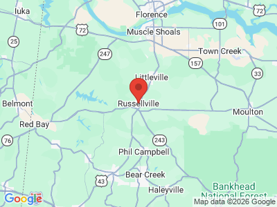
 Franklin County Map
Comprising approximately 643 square miles, Franklin County lies in the northwestern area of the state, wholly within the Highland Rim physiographic section. It is bounded to the east by Lawrence County, to the south by Winston and Marion Counties, to the west by Tishomingo and Itawamba counties, Mississippi, and to the north by Colbert County.
Franklin County Map
Comprising approximately 643 square miles, Franklin County lies in the northwestern area of the state, wholly within the Highland Rim physiographic section. It is bounded to the east by Lawrence County, to the south by Winston and Marion Counties, to the west by Tishomingo and Itawamba counties, Mississippi, and to the north by Colbert County.
Cedar Creek, a tributary of the Tennessee River, flows through the north-central area of the county, and Bear Creek, also a tributary of the Tennessee River, flows through the southwestern corner of the county. In the late 1960s, the Tennessee Valley Authority (TVA) built a reservoir on Bear Creek, creating Bear Creek Lake. In 1978, the TVA dammed Cedar Creek, creating Cedar Creek Lake. Mud Creek, a tributary of the Luxapilla Creek, runs through the eastern half of the county. U.S. 43 runs north-south through the west-central area of the county. Russellville Municipal Airport is the county's only public airport.
Events and Places of Interest
 Red Bay Museum
Franklin County's rural location offers several outdoor activities and attractions. Bear Creek is popular with canoers and kayakers and is bordered by scenic rock cliffs and challenging Class I to IV rapids at its upper end. Bear Creek Lake offers 8,000 acres of some of the cleanest recreational waters in the state and excellent bass fishing, with the average fish weighing in at 10 to 12 pounds. In addition, the lake offers skiing, swimming, boating, and campsites in more than five campgrounds. Dismals Canyon, a Registered National Natural Landmark, has been voted one of the country's most secluded and beautiful areas. The canyon includes waterfalls, more than 350 species of flora, and what are known colloquially as "dismalites," strange glowing insects called fungus gnats. In addition, a portion of the William Bankhead National Forest is located on the southeastern border of the county. Rock Bridge Canyon Equestrian Park is home to Alabama's largest rock formation, a giant sandstone cliff embedded with quartz deposits that rises 285 feet. Located near Hodges in the northern area of the county, the canyon also contains caves, springs, waterfalls, and an 82-foot-long natural bridge.
Red Bay Museum
Franklin County's rural location offers several outdoor activities and attractions. Bear Creek is popular with canoers and kayakers and is bordered by scenic rock cliffs and challenging Class I to IV rapids at its upper end. Bear Creek Lake offers 8,000 acres of some of the cleanest recreational waters in the state and excellent bass fishing, with the average fish weighing in at 10 to 12 pounds. In addition, the lake offers skiing, swimming, boating, and campsites in more than five campgrounds. Dismals Canyon, a Registered National Natural Landmark, has been voted one of the country's most secluded and beautiful areas. The canyon includes waterfalls, more than 350 species of flora, and what are known colloquially as "dismalites," strange glowing insects called fungus gnats. In addition, a portion of the William Bankhead National Forest is located on the southeastern border of the county. Rock Bridge Canyon Equestrian Park is home to Alabama's largest rock formation, a giant sandstone cliff embedded with quartz deposits that rises 285 feet. Located near Hodges in the northern area of the county, the canyon also contains caves, springs, waterfalls, and an 82-foot-long natural bridge.
For the more historically minded, the Red Bay Museum in Red Bay displays artifacts related to town history, most notably its most famous frequent resident, country music star Tammy Wynette. Every August, the town of Russellville hosts the annual Watermelon Festival, which features a pageant, a 5K race, arts and crafts, and tennis tournaments.
Additional Resources
- Heritage of Franklin County, Alabama. Clanton, Ala.: Heritage Publishing Consultants, Inc., 1999.
- Stewart, Margaret Estelle. Alabama's Franklin County: A History of Franklin County and Her People. Centre, Ala.: Stewart University Press, 1988.
External Links
- Franklin County
- Franklin County School System
- City of Russellville
- City of Red Bay
- Town of Hodges
- Town of Phil Campbell
- National Register of Historic Places: Franklin County
- Franklin County Chamber of Commerce
- Northwest-Shoals Community College
- Red Bay Museum
- Dismals Canyon National Natural Landmark
- Bankhead National Forest
- Visit North Alabama