Attalla
The city of Attalla is located in Etowah County west of the city of Gadsden. The town was a major rail and mining center in the nineteenth century and was home to Alabama‘s first hydroelectric dam. It has a mayor-council form of government.
Early History
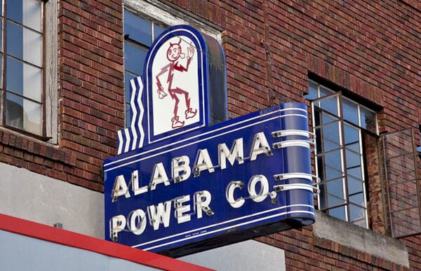
 Alabama Power Company Sign in Attalla
The earliest recorded settler in what is now Attalla was John Ratliffe, who moved to the area in 1800. In 1819, the first post office opened near the home of a settler named Bennett, and the town became known as Bennettville. Cherokee leader Capt. John Brown and his family lived in the settlement; his daughters, Catherine and Anna, would found the Creek Path Mission nearby in 1820, and his son, David, assisted in producing an early book on the Cherokee language. In 1825, French hero of the American Revolution Marquis de Lafayette visited the town during his tour of the United States, and French author François-René de Chateaubriand wrote the novel Atala, an Indian Maiden after visiting the town.
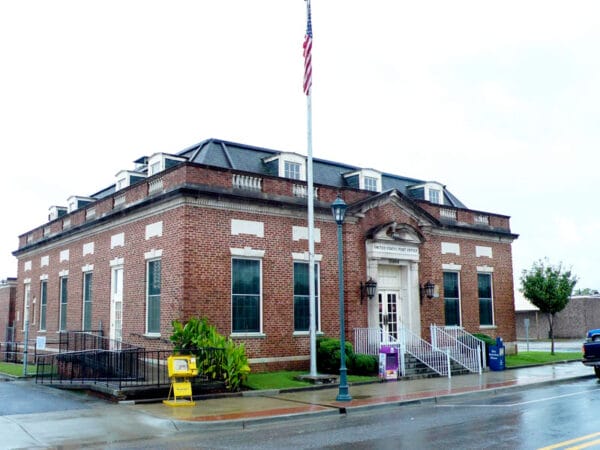
 Attalla Post Office
In 1830, John S. Moragne established the first mining operation, and the town soon became a mining center. By 1840, it was known as New Town or Newton and by 1849 boasted a stagecoach stop, a store, a post office, and an office of a justice of the peace. In 1851, the first church was constructed. By 1866, the town, then known as The Junction, was renamed Bainsville, and town leaders lobbied for the county seat to be located there. Nearby Gadsden was chosen instead, however. The first newspaper, the Union Republic, began publishing in 1870, and the Wills Valley Railroad ran a line from Chattanooga to the town about that time. In the ensuing decades, several more rail lines of the Louisville & Nashville Railroad would connect the town to various cities throughout the South, making it a major rail center. The town incorporated in 1872, when the first schools were established. By the turn of the twentieth century, the Hughes family had founded a brick plant, a cotton-processing facility, and a lumber business, joining the already thriving iron industry. In 1891, a fired destroyed much of the town, and many of the wooden structures were replaced with brick buildings.
In 1892, the town formally and officially adopted Attalla as its name; no firm source for the name is known but suggested origins include a corruption of the Cherokee word “otalie,” meaning “mountain.” The Hughes family donated land for a new high school that opened in 1910.
In 1941, the federal government constructed Camp Siebert on more than 37,000 acres straddling the Etowah and St. Clair County lines, with most of the camp lying within the city of Attalla. The site served as a training center for the Chemical Warfare Service of the Department of Defense until 1945.
Demographics
According to 2020 Census estimates, Attalla recorded a population of 5,885. Of that number, 78.9 percent of respondents identified themselves as white, 16.8 percent as African American, 4.6 percent as Hispanic, 2.7 percent as two or more races, and 1.0 percent as American Indian. The town’s median household income was $42,744, and the per capita income was $25,109.
Employment
According to 2020 Census estimates, the workforce in Attalla was divided among the following industrial categories:
- Educational services and health care and social assistance (29.5 percent)
- Arts, entertainment, and recreation, and accommodation and food services (13.0 percent)
- Other services, except public administration (13.0 percent)
- Manufacturing (12.8 percent)
- Retail trade (8.9 percent)
- Transportation and warehousing, and utilities (7.0 percent)
- Public administration (4.3 percent)
- Professional, scientific, and management, and administrative and waste management services (4.0 percent)
- Construction (2.5 percent)
- Finance and insurance, and real estate and rental and leasing (2.3 percent)
- Information (2.0 percent)
- Wholesale trade (0.6 percent)
Education
Public schools in Attalla are overseen by the Attalla City School District. The town has two elementary schools, one middle school, and one high school.
Transportation
Attalla is served by U.S. Highway 11, which runs northeast-southwest through the city, U.S. Highways 431/278, which runs east-west, Interstate 59, which runs northeast-southwest, and Interstate 759, which runs east. State Highway 79 runs west-southeast along the southern border of the town. Northeast Alabama Regional Airport, which serves general aviation, is located approximately five miles to the south.
Events and Places of Interest
 Tigers for Tomorrow at Untamed Mountain
Attalla is home to Tigers for Tomorrow at Untamed Mountain, an exotic animal park and rescue preserve that provides homes to confiscated and abandoned exotic animals. The park offers educational programming as well as recreational opportunities and animal viewing.
The U.S. Post Office building in Attalla, constructed in 1925, is on the National Register of Historic Places. Attalla Elementary School (c. 1935), the Old Keener House and Barn (c. 1850s), Seven Cedars (c. 1870), are on the Alabama Register of Landmarks and Heritage. The Wills Creek Vineyards and Winery is one of several wineries in north Alabama.
The town hosts its Attalla Heritage Day on the third Saturday in October; the event features arts and crafts, food, and live entertainment. Each December, the town celebrates the holiday season with the Attalla Downtown Christmas Open House and the Attalla Christmas Parade.


