Tennessee-Tombigbee Waterway
 Tennessee-Tombigbee Waterway
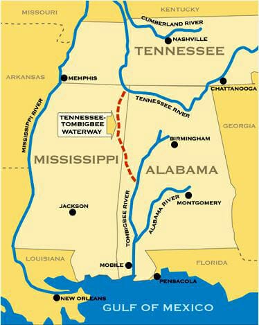
The Tennessee-Tombigbee Waterway is a 234-mile system of canals, locks, and dams that connect the Tennessee and Tombigbee rivers. It links commercial navigation from the nation’s midsection to the Gulf of Mexico and is administered by the U.S. Army Corps of Engineers and funded by tax dollars and user fees. Commonly known at the Tenn-Tom, the waterway begins on the Tennessee River at Pickwick Lake and flows south through northeast Mississippi and west-central Alabama near the Mississippi-Alabama border before connecting with the Tombigbee River near Demopolis, in Marengo County. The Tenn-Tom was controversial from its inception, and optimistic predictions of its economic benefits by the U.S. Army Corps of Engineers never materialized. Originally estimated to cost $323 million in 1970, the total cost at completion in 1984 was almost $2 billion.
Tennessee-Tombigbee Waterway
The Tennessee-Tombigbee Waterway is a 234-mile system of canals, locks, and dams that connect the Tennessee and Tombigbee rivers. It links commercial navigation from the nation’s midsection to the Gulf of Mexico and is administered by the U.S. Army Corps of Engineers and funded by tax dollars and user fees. Commonly known at the Tenn-Tom, the waterway begins on the Tennessee River at Pickwick Lake and flows south through northeast Mississippi and west-central Alabama near the Mississippi-Alabama border before connecting with the Tombigbee River near Demopolis, in Marengo County. The Tenn-Tom was controversial from its inception, and optimistic predictions of its economic benefits by the U.S. Army Corps of Engineers never materialized. Originally estimated to cost $323 million in 1970, the total cost at completion in 1984 was almost $2 billion.
Since the earliest days of Alabama’s territorial period, there had been a perceived need for a navigable link to connect the gap between the Tennessee River, which flows east to west through northern Alabama, and the Tombigbee River, which flows south through Alabama, eventually emptying into the Gulf of Mexico. The Tennessee River swings west toward Mississippi and comes within 500 miles of the Gulf of Mexico before turning north to travel several hundred miles to the Ohio River. Prior to the creation of the Tenn-Tom, commercial river traffic heading to the Gulf of Mexico had to travel hundreds of miles out of the way, despite its proximity to the Gulf.
In 1874, during the administration of Pres. Ulysses S. Grant, the federal government conducted a study to determine the feasibility of constructing such a waterway. The study determined that although construction of a waterway was feasible, lack of sufficient commercial traffic made it impractical. In 1913, the federal government again studied the possibility of constructing a waterway consisting of 65 dams and lift locks, but the U.S. Congress failed to appropriate funds for construction, and later studies failed to sway lawmakers.
 The Day We Got Tennessee-Tombigbee
Congress finally approved the waterway in 1946. The project faced opposition from some members of Congress, which again denied funding. In 1968, however, Pres. Lyndon B. Johnson approved funds to design and engineer the project, but the waterway continued to be controversial and was delayed by further legal challenges and funding shortages. A combination of environmental groups, the railroad industry, and members of Congress from other regions of the country were successful in blocking funding for years. To much of the public, the Tenn-Tom came to epitomize “pork-barrel politics” at its worst. The estimated economic benefits of the waterway by the Corps of Engineers were derided by opponents as unsupportable based on projected traffic volume, a charge that later proved to be true. The project was deauthorized at one point, and Pres. Jimmy Carter sought to cancel it.
The Day We Got Tennessee-Tombigbee
Congress finally approved the waterway in 1946. The project faced opposition from some members of Congress, which again denied funding. In 1968, however, Pres. Lyndon B. Johnson approved funds to design and engineer the project, but the waterway continued to be controversial and was delayed by further legal challenges and funding shortages. A combination of environmental groups, the railroad industry, and members of Congress from other regions of the country were successful in blocking funding for years. To much of the public, the Tenn-Tom came to epitomize “pork-barrel politics” at its worst. The estimated economic benefits of the waterway by the Corps of Engineers were derided by opponents as unsupportable based on projected traffic volume, a charge that later proved to be true. The project was deauthorized at one point, and Pres. Jimmy Carter sought to cancel it.
Organized support from powerful southern congressmen, including Alabama senator John Sparkman and Mississippi senator John C. Stennis, overcame the opposition. Even after approval, actual construction of the waterway did not commence until 1972, after being further delayed by lawsuits over the environmental impacts of the project. Construction proceeded over the next 12 years, consisting of 10 locks and dams and 234 miles of navigable waterway and the excavation of 310 million cubic yards of earth, more than was excavated for the Panama Canal. Eight railroad bridges and 14 highway bridges were either relocated or rebuilt. The single-greatest challenge was the construction and excavation of the so-called Divide Cut. This 29-mile portion of the waterway connected the Tenn-Tom with Pickwick Lake, which forms the border between Alabama and Mississippi in the northwestern corner of the state. The cut is 280 feet wide and at its deepest required the removal of earth to a depth of 175 feet. This single section of the waterway alone took eight years and required the removal of 150 million cubic yards of earth, almost half of the total excavated for the entire project. The Tenn-Tom encompasses 17 public ports and terminals, 110,000 acres of land, and another 88,000 acres managed by state conservation agencies for wildlife habitat preservation and recreational use. The elevation change between the two ends of the waterway is 341 feet, or a drop of 1.46 feet per mile.
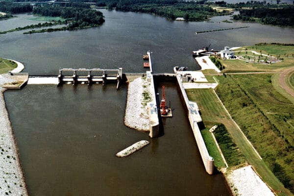 Tom Bevill Lock and Dam
The waterway was completed two years ahead of schedule on December 12, 1984, and on January 10, 1985, the towboat Eddie Wexler was the first commercial boat to sail upon it. Commercial barge traffic on the waterway during its first few years of operation was much lower than initially predicted because the country was in the midst of an economic recession. In 1988, a severe drought led to the closing of the Mississippi River to commercial traffic because of low water levels, shifting traffic temporarily to the Tenn-Tom.
Tom Bevill Lock and Dam
The waterway was completed two years ahead of schedule on December 12, 1984, and on January 10, 1985, the towboat Eddie Wexler was the first commercial boat to sail upon it. Commercial barge traffic on the waterway during its first few years of operation was much lower than initially predicted because the country was in the midst of an economic recession. In 1988, a severe drought led to the closing of the Mississippi River to commercial traffic because of low water levels, shifting traffic temporarily to the Tenn-Tom.
Today, the two primary commodities shipped via the Tenn-Tom are coal and timber products, together comprising about 70 percent of total commercial shipping on the waterway. Prior to its construction, however, the Corps of Engineers predicted that the waterway would float 27 million tons in its first year of operation. As the result of a variety of fluctuating economic conditions including low demand for coal and loss of overseas markets grain, however, the Tenn-Tom has peaked at only about 8 million tons per year thus far.
Additional Resources
Brose, David S. Yesterday’s River: The Archeology of Ten Thousand Years Along the Tennessee-Tombigbee Waterway. Cleveland, Ohio: Cleveland Museum of Natural History, 1991.
Stine, Jeffrey K. Mixing the Waters: Environment, Politics, and the Building of the Tennessee-Tombigbee Waterway. Akron, Ohio: University of Akron Press, 1993.