Fayette County
Located in northwestern Alabama, Fayette County is home to large portions of the Sipsey River, one of the longest free-flowing swamp and stream systems in the state. The county is governed by an elected six-member commission and includes four incorporated communities.
- Founding Date: December 20, 1824
- Area: 630 square miles
- Population: 16,321 (2020 Census estimate)
- Major Waterways: Sipsey River
- Major Highways: U.S. 43
- County Seat: Fayette
- Largest City: Fayette
History
 Fayette Art Museum
Fayette County was created by an act of the Alabama State Legislature on December 20, 1824, from portions of Tuscaloosa and Marion counties. The county was named for French general and Revolutionary war hero Marquis de Lafayette, who was touring Alabama at the time of the county's creation. The first settlement around what is now the county seat, Fayette, was originally called LaFayette; on January 15, 1821, the town was incorporated and renamed Fayette Court House. The present courthouse was built in 1911. In 1912, the Church of Christ opened the coeducational Alabama Christian College in the town of Berry in the eastern portion of the county.
Fayette Art Museum
Fayette County was created by an act of the Alabama State Legislature on December 20, 1824, from portions of Tuscaloosa and Marion counties. The county was named for French general and Revolutionary war hero Marquis de Lafayette, who was touring Alabama at the time of the county's creation. The first settlement around what is now the county seat, Fayette, was originally called LaFayette; on January 15, 1821, the town was incorporated and renamed Fayette Court House. The present courthouse was built in 1911. In 1912, the Church of Christ opened the coeducational Alabama Christian College in the town of Berry in the eastern portion of the county.
On April 27, 2011, a massive storm, causing numerous powerful tornadoes, struck the southeastern United States. More than 250 people were killed in Alabama, including four people in the community of Berry in Fayette County.
Major Cities and Demographics
According to 2020 Census estimates, the population of Fayette County was 16,321. Approximately 84.6 percent of respondents identified themselves as white, 12.2 percent as African American, 2.5 percent as two or more races, 0.7 percent as Asian, and 0.5 percent as Hispanic. The county seat, Fayette, had a population of 4,329. Other population centers in the county include Berry, Glen Allen, and Belk. The median household income was $41,469, compared with $52,035 for the state as a whole, and the per capita income was $23,389, compared with $28,934 for the state as a whole.
Economy
 Fayette County Courthouse
During the nineteenth century, the economy of Fayette County was centered around farming, with cotton and corn being the primary cash crops. The Richmond and Danville Extension Company completed a line of the Georgia Pacific Railroad through Fayette County in 1887. The line extended from Atlanta, Georgia, to Greenville, Mississippi, and was later taken over by Southern Railway Company. Current agricultural crops include cotton, soybeans, and corn. Clothing, latex gloves, truckbeds, hardwood flooring, and manufactured homes and lumber are major industries in the county.
Fayette County Courthouse
During the nineteenth century, the economy of Fayette County was centered around farming, with cotton and corn being the primary cash crops. The Richmond and Danville Extension Company completed a line of the Georgia Pacific Railroad through Fayette County in 1887. The line extended from Atlanta, Georgia, to Greenville, Mississippi, and was later taken over by Southern Railway Company. Current agricultural crops include cotton, soybeans, and corn. Clothing, latex gloves, truckbeds, hardwood flooring, and manufactured homes and lumber are major industries in the county.
Employment
According to 2020 Census estimates, the workforce in Fayette County was divided among the following industrial categories:
- Manufacturing (26.2 percent)
- Educational services, and health care and social assistance (23.0 percent)
- Retail trade (15.8 percent)
- Transportation and warehousing, and utilities (6.3 percent)
- Other services, except public administration (4.6 percent)
- Construction (4.3 percent)
- Arts, entertainment, recreation, and accommodation and food services (4.0 percent)
- Professional, scientific, management, and administrative and waste management services (4.0 percent)
- Finance and insurance, and real estate, rental, and leasing (3.3 percent)
- Public administration (2.3 percent)
- Agriculture, forestry, fishing and hunting, and extractive (1.6 percent)
- Wholesale trade (2.6 percent)
- Information (2.0 percent)
Education
The Fayette County School System oversees six schools. Bevill State Community College maintains a campus in Fayette.
Geography
 Fayette County Map
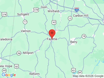
Comprising approximately 630 square miles, Fayette County lies in the northwestern area of the state, with the western section located in the East Gulf Coast physiographic section and the east in the Cumberland Plateau. It is bounded to the east by Walker County, to the south by Tuscaloosa and Pickens Counties, to the west by Lamar County, and to the north by Marion County.
Fayette County Map
Comprising approximately 630 square miles, Fayette County lies in the northwestern area of the state, with the western section located in the East Gulf Coast physiographic section and the east in the Cumberland Plateau. It is bounded to the east by Walker County, to the south by Tuscaloosa and Pickens Counties, to the west by Lamar County, and to the north by Marion County.
The Sipsey River, a tributary of the Tombigbee River flows through the center of the county, while the North River, a tributary of the Upper Black Warrior River, flows through the eastern half. Luxapalila Creek, a tributary of the Upper Tombigbee River, flows south to north through the western half of the county. U.S. 43 runs south to north through the north-central and eastern portions of the county.
Events and Places of Interest
The Sipsey River, which flows through the entirety of central Fayette County, is one of the last free-flowing swamp streams in Alabama. One of the largest bottomland wetlands, the river is highly prized among canoers for its scenery. The river also offers fishing for such species as catfish, crappie, pickerel, bream, and largemouth and spotted bass. The area also offers waterfowl and deer hunting. The Fayette County Depot Museum, housed in a historic train station, interprets the city's and county's history. The Fayette Art Museum and Civic Center features folk art by local artists including outsider artists Lois Wilson and Jimmy Lee Sudduth, whose works hang in the Smithsonian.
Additional Resources
- Heritage of Fayette County, Alabama. Clanton, Ala.: Heritage Publishing Consultants, Inc., 1999.