Cleburne County
 Talladega National Forest
Located in the northeastern area of the state, Cleburne County contains large portions of the Talladega National Forest as well as Alabama's highest point, Cheaha Mountain, the centerpiece of Cheaha State Park. During the nineteenth century, the area was a leading producer of valuable minerals, including gold, copper, and mica. Today, Cleburne County's many parks and lakes offer visitors abundant outdoor activities. The county is governed by an elected four-member commission.
Talladega National Forest
Located in the northeastern area of the state, Cleburne County contains large portions of the Talladega National Forest as well as Alabama's highest point, Cheaha Mountain, the centerpiece of Cheaha State Park. During the nineteenth century, the area was a leading producer of valuable minerals, including gold, copper, and mica. Today, Cleburne County's many parks and lakes offer visitors abundant outdoor activities. The county is governed by an elected four-member commission.
- Founding Date: December 6, 1866
- Area: 561 square miles
- Population: 14,952 (2020 Census estimate)
- Major Waterways: Tallapoosa River
- Major Highways: I-20, U.S. 78, U.S. 431
- County Seat: Heflin
- Largest City: Heflin
History
 Cleburne County Courthouse
Cleburne County was created by an act of the Alabama State Legislature on December 6, 1866, from portions of Randolph, Talladega, and Calhoun counties. The county is named for Confederate general Patrick Cleburne, of Arkansas, who was killed at the Battle of Franklin in 1864. Cleburne County is located on what was once Creek and Cherokee Indian land. The first settlers came to the area in the 1820s and named the town of Edwardsville as the county seat. Settlement in the area remained sparse until the 1830s, when gold was discovered in the vicinity of Arbacoochee and Chulafinnee in the southern part of the county. By 1836, some 5,000 miners had moved to the area in hopes of striking it rich. The discovery of gold in California in 1849 eclipsed mining in Cleburne County, but it is estimated that more than $1 million in gold was mined out of its streams. Copper and mica were also found in the southern part of the county in the late nineteenth century, but little effort was made to capitalize on the discovery.
Cleburne County Courthouse
Cleburne County was created by an act of the Alabama State Legislature on December 6, 1866, from portions of Randolph, Talladega, and Calhoun counties. The county is named for Confederate general Patrick Cleburne, of Arkansas, who was killed at the Battle of Franklin in 1864. Cleburne County is located on what was once Creek and Cherokee Indian land. The first settlers came to the area in the 1820s and named the town of Edwardsville as the county seat. Settlement in the area remained sparse until the 1830s, when gold was discovered in the vicinity of Arbacoochee and Chulafinnee in the southern part of the county. By 1836, some 5,000 miners had moved to the area in hopes of striking it rich. The discovery of gold in California in 1849 eclipsed mining in Cleburne County, but it is estimated that more than $1 million in gold was mined out of its streams. Copper and mica were also found in the southern part of the county in the late nineteenth century, but little effort was made to capitalize on the discovery.
 Shoal Creek Church
In the late-nineteenth century, a winery in the town of Fruithurst briefly became a popular tourist destination. The winery failed, however, when disease wiped out the grape harvest in the early twentieth century. In 1882, the Georgia-Pacific Railroad was extended from Atlanta to the town of Heflin, in the west-central part of the county. In 1905, the county held an election to decide whether to move the county seat from Edwardsville to Heflin. The election results and a subsequent Alabama Supreme Court ruling favored Heflin, which remains the county seat.
Shoal Creek Church
In the late-nineteenth century, a winery in the town of Fruithurst briefly became a popular tourist destination. The winery failed, however, when disease wiped out the grape harvest in the early twentieth century. In 1882, the Georgia-Pacific Railroad was extended from Atlanta to the town of Heflin, in the west-central part of the county. In 1905, the county held an election to decide whether to move the county seat from Edwardsville to Heflin. The election results and a subsequent Alabama Supreme Court ruling favored Heflin, which remains the county seat.
Major Cities and Demographics
According to 2020 Census estimates, Cleburne County recorded a population of 14,952. Approximately 93.3 percent of respondents identified themselves as white, 2.6 percent as African American, 2.5 percent Hispanic, 2.0 as two or more races, and 0.1 as Native American. The county seat, Heflin, had a population of 3,453. Other population centers include Ranburne, Fruithurst, and Edwardsville. The median household income in Cleburne County was $46,320, compared with $52,035 for the state as a whole, and the per capita income was $24,723, compared with $28,934 for the state as a whole.
Economy
 Heflin
Cleburne County was largely agricultural during the nineteenth century. Farmers grew corn, oats, wheat, and cotton and raised cattle. During the 1830s, the discovery of gold in the southern half of the county brought thousands of miners to the area, but the enterprise failed when miners left for the California gold rush of 1849. During the nineteenth and early twentieth centuries, several economic ventures, including copper and mica mining and winemaking, were attempted, but they failed due to poor transportation and agricultural disease. The heavy forestation of the county made it ideal for the timber and pulpwood industries, which soon moved into the area. In the mid-1950s, the county became known as the "Broiler Capital of Alabama" when a large poultry-processing plant was constructed. The plant was extensively damaged by fire in September 2006, and its owner, Tyson Foods Inc., closed the facility. Other manufacturers include Heflin Chenille, the second largest producer of bathrobes, and Sewell Manufacturing, which produces men's and women's suits.
Heflin
Cleburne County was largely agricultural during the nineteenth century. Farmers grew corn, oats, wheat, and cotton and raised cattle. During the 1830s, the discovery of gold in the southern half of the county brought thousands of miners to the area, but the enterprise failed when miners left for the California gold rush of 1849. During the nineteenth and early twentieth centuries, several economic ventures, including copper and mica mining and winemaking, were attempted, but they failed due to poor transportation and agricultural disease. The heavy forestation of the county made it ideal for the timber and pulpwood industries, which soon moved into the area. In the mid-1950s, the county became known as the "Broiler Capital of Alabama" when a large poultry-processing plant was constructed. The plant was extensively damaged by fire in September 2006, and its owner, Tyson Foods Inc., closed the facility. Other manufacturers include Heflin Chenille, the second largest producer of bathrobes, and Sewell Manufacturing, which produces men's and women's suits.
Employment
According to 2020 Census estimates, the workforce in Cleburne County was divided among the following industrial categories:
- Manufacturing (20.8 percent)
- Educational services, and health care and social assistance (18.0 percent)
- Construction (12.2 percent)
- Retail trade (8.4 percent)
- Professional, scientific, management, and administrative and waste management services (7.3 percent)
- Arts, entertainment, recreation, and accommodation and food services (6.4 percent)
- Public administration (6.0 percent)
- Transportation and warehousing, and utilities (5.0 percent)
- Finance and insurance, and real estate, rental, and leasing (4.1 percent)
- Other services, except public administration (4.1 percent)
- Wholesale trade (4.1 percent)
- Agriculture, forestry, fishing and hunting, and extractive (3.4 percent)
- Information (0.3 percent)
Education
The Cleburne County School System oversees eight schools.
Geography
 Cleburne County Map
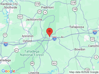
Comprising approximately 561 square miles, Cleburne County lies in the northeastern area of the state, wholly within the Piedmont physiographic section. It is bounded to the north by Cherokee County, to the east by the state of Georgia, to the south by Randolph and Clay Counties, and to the west by Talladega and Calhoun Counties. The western portion of the county is located within the Talladega National Forest.
Cleburne County Map
Comprising approximately 561 square miles, Cleburne County lies in the northeastern area of the state, wholly within the Piedmont physiographic section. It is bounded to the north by Cherokee County, to the east by the state of Georgia, to the south by Randolph and Clay Counties, and to the west by Talladega and Calhoun Counties. The western portion of the county is located within the Talladega National Forest.
The Tallapoosa River runs along the southeastern part of the county. Interstate 20 is Cleburne County's major transportation route, running east-west through the southern part of the county. U.S. 78 and U.S 431 are the county's other routes.
Events and Places of Interest
 Cheaha Mountain View
The Shoal Creek Ranger District of the Talladega National Forest covers a large portion of the western half of Cleburne County and provides scenic views, hiking, camping, and horseback riding, and final stretch of the 102-mile Pinhoti Trail ends in the county. In addition, portions of Cheaha State Park are located in Cleburne County. High Rock Lake and Morgan Lake, located north of Heflin, are ideal for catfish, bass, and bream fishing. Heflin's Parks and Recreation Department hosts the annual Outdoor Jamboree in early fall, which features live music, a beauty pageant, food, arts and crafts, an archery tournament, and a children's carnival.
Cheaha Mountain View
The Shoal Creek Ranger District of the Talladega National Forest covers a large portion of the western half of Cleburne County and provides scenic views, hiking, camping, and horseback riding, and final stretch of the 102-mile Pinhoti Trail ends in the county. In addition, portions of Cheaha State Park are located in Cleburne County. High Rock Lake and Morgan Lake, located north of Heflin, are ideal for catfish, bass, and bream fishing. Heflin's Parks and Recreation Department hosts the annual Outdoor Jamboree in early fall, which features live music, a beauty pageant, food, arts and crafts, an archery tournament, and a children's carnival.
Additional Resources
- Heritage of Cleburne County Alabama. Clanton, Ala.: Heritage Publishing Consultants, Inc., 1998.
- Stewart, Margaret Estelle. Alabama's Cleburne County: A History of CleburneCounty and Her People. Centre, Ala.: Stewart University Press, 1982.