Cumberland Plateau Physiographic Section
 Alabama Physiographic Sections Map
The Cumberland Plateau physiographic section is the most southerly part of the Appalachian Plateaus province of the Appalachian Highlands Region. Hereafter called the Cumberland Plateau, the section is identified by its pattern of relief features and landforms, which differ significantly from those of adjacent sections. It occupies about 15 percent of the state and occurs as a roughly northeast-oriented rectangular area in central and northeastern Alabama, encompassing mainly Jackson, DeKalb, Marshall, Blount, Cullman, Winston and Walker Counties and runs into northeastern Georgia and Tennessee. The Cumberland Plateau borders the Highland Rim section to the north, the Valley and Ridge to the southeast, and the Cumberland Plateau to the southwest. The landscape consists of flat-topped, high-elevation plateaus separated by deep, steep-sided valleys. The plateaus slope gently from the northeast to the southwest. The highest elevations are above 1,500 feet in DeKalb and eastern Madison Counties, and the lowest elevations are about 200 feet, near Holt Lock and Dam in Tuscaloosa County.
Alabama Physiographic Sections Map
The Cumberland Plateau physiographic section is the most southerly part of the Appalachian Plateaus province of the Appalachian Highlands Region. Hereafter called the Cumberland Plateau, the section is identified by its pattern of relief features and landforms, which differ significantly from those of adjacent sections. It occupies about 15 percent of the state and occurs as a roughly northeast-oriented rectangular area in central and northeastern Alabama, encompassing mainly Jackson, DeKalb, Marshall, Blount, Cullman, Winston and Walker Counties and runs into northeastern Georgia and Tennessee. The Cumberland Plateau borders the Highland Rim section to the north, the Valley and Ridge to the southeast, and the Cumberland Plateau to the southwest. The landscape consists of flat-topped, high-elevation plateaus separated by deep, steep-sided valleys. The plateaus slope gently from the northeast to the southwest. The highest elevations are above 1,500 feet in DeKalb and eastern Madison Counties, and the lowest elevations are about 200 feet, near Holt Lock and Dam in Tuscaloosa County.
 Cumberland Plateau Cross-Section
The landforms are the result of differential erosion of the underlying Paleozoic rocks in the section, which range from Cambrian to Pennsylvanian in age (approximately 550 to 290 million years before the present). The most resistant rocks are sandstones of various ages, and these are what form the ridges. Pennsylvanian sandstones belonging to the Pottsville Formation underlie the major plateaus. The valleys cut through softer shale, limestone, and dolomite. Of these three, limestone is most easily weathered and eroded, and thus the deepest valleys are cut through this rock type. The plateaus of Lookout Mountain and Sand Mountain developed on down arches in rock layers known as synclines. The Wills, Murphrees and Sequatchie Valleys developed where the presence of anticlines, which are up arch folds in rock layers, exposed the more easily eroded rocks.
Cumberland Plateau Cross-Section
The landforms are the result of differential erosion of the underlying Paleozoic rocks in the section, which range from Cambrian to Pennsylvanian in age (approximately 550 to 290 million years before the present). The most resistant rocks are sandstones of various ages, and these are what form the ridges. Pennsylvanian sandstones belonging to the Pottsville Formation underlie the major plateaus. The valleys cut through softer shale, limestone, and dolomite. Of these three, limestone is most easily weathered and eroded, and thus the deepest valleys are cut through this rock type. The plateaus of Lookout Mountain and Sand Mountain developed on down arches in rock layers known as synclines. The Wills, Murphrees and Sequatchie Valleys developed where the presence of anticlines, which are up arch folds in rock layers, exposed the more easily eroded rocks.
Districts
 Cumberland Plateau Districts
The Cumberland Plateau is divided into eight districts: Sand Mountain, Lookout Mountain, Blount Mountain, Warrior Basin, Jackson County Mountains, Murphrees Valley, Wills Valley, and Sequatchie Valley.
Cumberland Plateau Districts
The Cumberland Plateau is divided into eight districts: Sand Mountain, Lookout Mountain, Blount Mountain, Warrior Basin, Jackson County Mountains, Murphrees Valley, Wills Valley, and Sequatchie Valley.
The Sand Mountain district separates the valleys of the Tennessee River and Big Wills Creek, stretching for about 90 miles from the Alabama-Tennessee-Georgia border to near Cleveland, in Blount County. It is about 15 miles wide at its widest point and slopes gently to the southwest, with elevations decreasing from 1,960 feet at Fox Mountain (DeKalb County) to about 500 feet in Blount County. Its southwestern boundary is the Warrior Basin, and its surface is flat and unremarkable, cut by very few streams.
Lookout Mountain lies to the east of Wills Valley and stretches from the Georgia state border in DeKalb County to Gadsden, in Etowah County. It continues through northwest Georgia to Chattanooga, Tennessee. At less than 10 miles wide and under 50 miles long, Lookout Mountain is narrower and shorter than Sand Mountain. The plateau tilts toward both the southwest and the southeast. Elevations along its northwestern edge overlooking Wills Valley decrease from about 1,800 feet above sea level at the Alabama-Georgia line to about 900 feet at Gadsden. The southeastern edge of the plateau is between 100 and 300 feet lower than the northwest edge. Along most of its length, the interior of the plateau sags between 100 to 200 feet below the southeastern edge.
 Polygonal Rock Face
The Blount Mountain district's plateau separates the Murphrees Valley district from the southern end of the Wills Valley district and the Birmingham-Big Canoe Valley district of the Tennessee Valley and Ridge section. The plateau is shaped like an elongated saucer that slopes generally to the southwest and abuts the Sand Mountain district to the northeast near Carlisle, in Etowah County. Horse Pens 40 nature park, near Steele, in St. Clair County, is home to a spectacular landform on the southern slope of Chandler Mountain, a part of the Blount Mountain district. There sandstones and shales with well-developed joints (sets of parallel fractures or cracks) have eroded along the joint surfaces to form polygonal blocks separated by deep gullies.
Polygonal Rock Face
The Blount Mountain district's plateau separates the Murphrees Valley district from the southern end of the Wills Valley district and the Birmingham-Big Canoe Valley district of the Tennessee Valley and Ridge section. The plateau is shaped like an elongated saucer that slopes generally to the southwest and abuts the Sand Mountain district to the northeast near Carlisle, in Etowah County. Horse Pens 40 nature park, near Steele, in St. Clair County, is home to a spectacular landform on the southern slope of Chandler Mountain, a part of the Blount Mountain district. There sandstones and shales with well-developed joints (sets of parallel fractures or cracks) have eroded along the joint surfaces to form polygonal blocks separated by deep gullies.
The Warrior Basin district occupies most of the Cumberland Plateau in central and western Alabama. It stretches from just south of the Tennessee River in Morgan County to Tuscaloosa. Its northern boundary with the Jackson County Mountains is the first cliff face, or scarp, south of the Tennessee River. Farther to the west, it is bounded by a scarp that forms the southern edge of Moulton Valley. Its eastern boundary is a low ridge, called Rock Mountain and Sand Mountain in Blount and Jefferson counties, respectively. (Sand Mountain forms the northwestern horizon when looking in that direction from downtown Birmingham.) The southwestern boundary with the East Gulf Coastal Plain occurs from about Vance, in Tuscaloosa County, to Hamilton, in Marion County.
Unlike the other upland sections in the Cumberland Plateau, the surface of the Jackson County Mountains district is highly irregular, consisting of isolated, flat-topped remnants of the former plateau cut by steep-sided valleys. Heights of individual peaks reflect whether or not the original sandstone layer that capped the peaks is still present as well as the degree of erosion of the underlying Mississippian shales and limestones. The remnants of the Pottsville Formation occur at elevations ranging from about 1,200 feet above sea level along the Tennessee River to more than 1,700 feet along the Alabama-Tennessee border, indicating an original plateau that sloped from northeast to southwest.
The Murphrees, Wills, and Sequatchie Valley districts are three roughly parallel valleys that run northeast-southwest. Each formed on an anticline, an arch-shaped fold in a rock layer, capped in the Pottsville Sandstone that was eroded away over time. As a result, water action cut deep, narrow valleys into the uplands areas. These valleys are narrow (generally less than eight miles wide) and deep, with nearly vertical sides that commonly descend between 500 and 600 feet below the uplands.
The Murphrees Valley district is the smallest, being only about 30 miles long and about three miles wide. It is bounded by the Straight and Red Mountains. The valley begins near Mountainburg, in Etowah County, and joins Big Canoe Valley just north of Pinson, in Jefferson County.
 Chandler Mountain
Wills Valley runs astride I-59 from the town of Attalla, in Etowah County, to the Alabama-Georgia border. The valley is about 70 miles long and ranges in width from less than two miles in the southwest to about six miles across in the northeast. North of Attalla, the northeasterly-trending Big Ridge bisects the district, separating the Big and Little Wills creeks. Wills Valley joins Big Canoe Valley of the Tennessee Valley and Ridge section along a line from the foot of Chandler Mountain's northeastern scarp through Attalla to Gadsden, but this boundary is not well defined topographically.
Chandler Mountain
Wills Valley runs astride I-59 from the town of Attalla, in Etowah County, to the Alabama-Georgia border. The valley is about 70 miles long and ranges in width from less than two miles in the southwest to about six miles across in the northeast. North of Attalla, the northeasterly-trending Big Ridge bisects the district, separating the Big and Little Wills creeks. Wills Valley joins Big Canoe Valley of the Tennessee Valley and Ridge section along a line from the foot of Chandler Mountain's northeastern scarp through Attalla to Gadsden, but this boundary is not well defined topographically.
Sequatchie Valley widens to the northeast, narrows near Blountsville, in Blount County, and then reaches a width of eight miles north of Lake Guntersville. The valley extends 90 miles northeast to Bridgeport, in Jackson County and continues into Tennessee.
River Systems
The Warrior and Tennessee River systems drain most of the Cumberland Plateau. Each has a distinctive drainage pattern.
 River Drainage Systems of the Cumberland Plateau
The Tennessee River flows southwest in Sequatchie Valley from the Alabama-Tennessee border to Guntersville, in Marshall County, where it abruptly changes direction and flows northwest through the Jackson County Mountains and into the Highland Rim physiographic section. The change in direction has been attributed to a large northwest-southeast-trending structure called the Anniston Cross-Strike Structural Discontinuity, a northwest-trending zone of highly crushed rocks. This geologic feature caused a zone of weakness into which the river eroded.
River Drainage Systems of the Cumberland Plateau
The Tennessee River flows southwest in Sequatchie Valley from the Alabama-Tennessee border to Guntersville, in Marshall County, where it abruptly changes direction and flows northwest through the Jackson County Mountains and into the Highland Rim physiographic section. The change in direction has been attributed to a large northwest-southeast-trending structure called the Anniston Cross-Strike Structural Discontinuity, a northwest-trending zone of highly crushed rocks. This geologic feature caused a zone of weakness into which the river eroded.
The Black Warrior system has two different flow patterns. Its eastern tributaries, the Mulberry Fork and Locust Fork, rise between Cullman and Guntersville and flow southwest in a trellis pattern consisting of long, relatively straight stream segments with smaller short tributaries joining at right angles. The northern tributary, the Sipsey Fork, flows in a very distinctive rectangular pattern. Several individual straight stream segments flow either southwesterly or southeasterly and make approximately right-angle bends at various points.
One particularly scenic area in the Cumberland Plateau occurs where the Little River has cut into the plateau, forming the Little River Canyon. Below the falls at De Soto State Park, the river has cut about 90 feet into the plateau and flows at an elevation of 1,143 feet. By the time the river enters the Coosa River valley west of Hurley in Cherokee County, its bed has descended about 500 feet and flows at an elevation of 650 feet. The valley profile is V-shaped, with the river occupying all of the lowlands. The canyon is about 1,200 feet wide at De Soto Falls and widens to about 2,600 feet at its mouth, near Hurley. The river flows to the southwest throughout most of its course in the canyon, cutting through the sandstones of the Pottsville Formation. Numerous waterfalls occur along its course and tributaries flow off the plateau to join the main part of the river. About one mile before it exits the canyon, the river changes course to the southeast in an area where it has begun to erode the softer Mississippian shale underlying the Pottsville sandstone.
Natural Resources
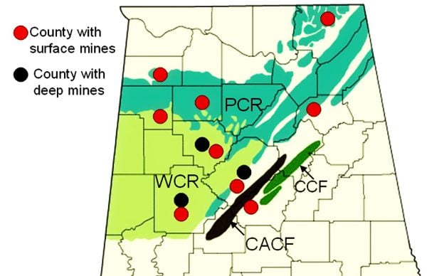 Coal Deposits in North Alabama
The Cumberland Plateau contains economic deposits of Pennsylvanian-aged bituminous coal. The deposits are divided geographically into four regions, or fields: the Warrior Basin, Plateau, Cahaba, and Coosa. During the nineteenth century, the Coosa and Cahaba fields were the source of coal for Alabama's fledgling iron industry and for the Confederacy. Much of the coal mining in the twentieth century was surface mining, and the scars can be seen throughout the area. Recent reclamation efforts in many places have begun to restore the landscape. Methane is also an important economic resource in the Cumberland Plateau. A by-product of coal formation, methane gas accumulates in and around the coal beds and is thus called coalbed methane. The gas is extracted from several areas in the Warrior Basin, mainly in Tuscaloosa, Walker and Jefferson Counties.
Coal Deposits in North Alabama
The Cumberland Plateau contains economic deposits of Pennsylvanian-aged bituminous coal. The deposits are divided geographically into four regions, or fields: the Warrior Basin, Plateau, Cahaba, and Coosa. During the nineteenth century, the Coosa and Cahaba fields were the source of coal for Alabama's fledgling iron industry and for the Confederacy. Much of the coal mining in the twentieth century was surface mining, and the scars can be seen throughout the area. Recent reclamation efforts in many places have begun to restore the landscape. Methane is also an important economic resource in the Cumberland Plateau. A by-product of coal formation, methane gas accumulates in and around the coal beds and is thus called coalbed methane. The gas is extracted from several areas in the Warrior Basin, mainly in Tuscaloosa, Walker and Jefferson Counties.
Additional Resources
- Adams, G.I., et al. Geology of Alabama. Geological Survey of Alabama Special Report 14. Tuscaloosa, Ala.: Geological Survey of Alabama, 1926.
- Coleman, J. L., et al. "Structure of the Wills Valley Anticline-Lookout Mountain Syncline between the Rising Fawn and Anniston CSDs, Northeast Alabama." Geological Society of Alabama Guidebook 25. Tuscaloosa: Geological Society of Alabama, 1988.
- Lacefield, J. Lost Worlds in Alabama Rocks. Tuscaloosa: Alabama Museum of Natural History, 2013.